Patent / CN207798472U
Environmental Monitoring UAV System
An unmanned aerial vehicle system for environmental and water-quality monitoring. The design combines buoyant landing gear, water-quality sensors, GPS and wireless data transmission to support sampling and monitoring at water surfaces.
Abstract
English translationThis utility model belongs to the fields of unmanned aerial vehicles and environmental monitoring. It discloses an environmental monitoring UAV system comprising a frame with buoyant landing gear fixed underneath. A fairing is fixed to one end of the frame and contains a GPS antenna. A wireless data-transmission module and a main control chip are installed on one side of the fairing, and a water-quality sensor is installed underneath it. The main control chip is connected to the GPS antenna, wireless data-transmission module and water-quality sensor. The utility model avoids the need for monitoring personnel to travel long distances to sampling sites and can reach rivers, lakes or sea areas that are difficult for people to access. It offers more flexible and efficient mobility than manual work or other transport methods, with few geographical restrictions.
Patent Drawings
1 sheets · 2 figuresPublished drawings with English labels. Select a sheet to enlarge it here.
 Enlarge
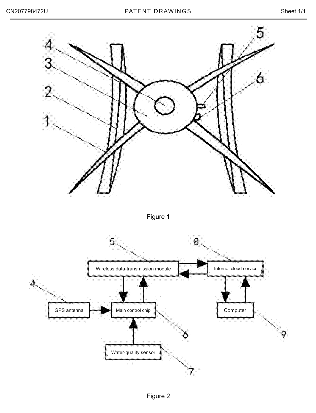
Figure 1 is a schematic structural view of the environmental monitoring UAV system in an embodiment of this utility model.
Figure 2 is a schematic diagram of the operating principle of the environmental monitoring UAV system in an embodiment of this utility model.
Claims
6 claims · English translation- 1. An environmental monitoring UAV system comprising a frame (1) and a computer (9), wherein buoyant landing gear (2) is fixed underneath the frame (1); a fairing (3) is fixed to one end of the frame (1); a GPS antenna (4) is installed inside the fairing (3); a wireless data-transmission module (5) and a main control chip (6) are installed on one side of the fairing (3); a water-quality sensor (7) is installed underneath the fairing (3); and the main control chip (6) is connected to the GPS antenna (4), wireless data-transmission module (5) and water-quality sensor (7).
- 2. The environmental monitoring UAV system according to claim 1, wherein the wireless data-transmission module (5) operates in a frequency band between 170 and 433 MHz.
- 3. The environmental monitoring UAV system according to claim 1, wherein the main control chip (6) communicates with the wireless data-transmission module (5) and water-quality sensor (7) over an I2C bus.
- 4. The environmental monitoring UAV system according to claim 1, wherein the frame (1) carries several sampling modules, each of which can accommodate multiple sampling bottles for collecting water samples.
- 5. The environmental monitoring UAV system according to claim 4, wherein each sampling bottle has a capacity between 50 and 200 mL.
- 6. The environmental monitoring UAV system according to claim 1, wherein the computer (9) uses application software developed in C++/C# to organise data automatically and save it as electronic charts. The electronic files can be uploaded to an Internet cloud service (8) connected to a PHP-based online platform, through which users can access the automatically organised water-quality data using WeChat or a browser.
Description
Complete specification · English translationTechnical field
This utility model relates specifically to an environmental monitoring UAV system and belongs to the fields of unmanned aerial vehicles and environmental monitoring.
Background
Governments and the public are increasingly concerned with environmental improvement and pollution control. Monitoring and using environmental data directly affects the efficiency of this work: effective responses require an understanding of environmental conditions. Such information also concerns the public's right to know about its surroundings.
National investment in environmental monitoring has increased in recent years, with the water-quality monitoring market growing annually. However, investigations indicate limited innovation in monitoring methods and difficulty balancing cost and efficiency; some existing methods cannot meet application needs. For outdoor water-quality monitoring, common automatic monitoring stations are expensive, measure a limited range of data, have low reliability and are difficult to maintain. Manual sampling is inefficient and slow. Incorporating UAV technology can balance efficiency and cost: a UAV can carry several instruments, land on a designated water surface to collect comprehensive data, and return water samples for analysis. This approach is limited to open-air water environments. UAV flight characteristics restrict operations over narrow, turbulent or complex waters and in extreme weather. It therefore remains subject to the conditions in which a UAV can operate.
Technical solution
The utility model addresses the shortcomings of existing technology by providing an environmental monitoring UAV system. It avoids long journeys by personnel to sampling sites and can reach rivers, lakes and sea areas that are difficult for people to access. With few geographical restrictions, it offers more flexible and efficient mobility than manual work or other transport methods, addressing the problems described in the background.
The following technical solution is provided to address these problems:
The environmental monitoring UAV system comprises a frame and a computer. Buoyant landing gear is fixed underneath the frame, and a fairing is fixed to one end. A GPS antenna is installed inside the fairing; a wireless data-transmission module and a main control chip are installed on one side; and a water-quality sensor is installed underneath. The main control chip is connected to the GPS antenna, wireless data-transmission module and water-quality sensor.
In a preferred arrangement, the wireless data-transmission module operates in a frequency band between 170 and 433 MHz.
In a preferred arrangement, the main control chip communicates with the wireless data-transmission module and water-quality sensor over an I2C bus.
In a preferred arrangement, the frame carries several sampling modules, each of which can accommodate multiple sampling bottles for collecting water samples.
In a preferred arrangement, each sampling bottle has a capacity between 50 and 200 mL.
In a preferred arrangement, the computer uses application software developed in C++/C# to organise data automatically and save it as electronic charts. Electronic files can be uploaded to an Internet cloud service connected to a PHP-based online platform. Users can access the automatically organised water-quality data through WeChat or a browser.
The environmental monitoring UAV system avoids the need for personnel to travel long distances to sampling sites and can reach rivers, lakes or sea areas that are difficult for people to access. With few geographical restrictions, it offers more flexible and efficient mobility than manual work or other transport methods. Its modular functional design accommodates different mission modules and offers cost and efficiency advantages for diverse tasks. The UAV platform is recovered after each mission, making equipment maintenance convenient.
Description of drawings
The accompanying drawings assist understanding of this utility model and form part of the specification. Together with the embodiments, they explain the utility model without limiting it.
In the drawings:
Figure 1 is a schematic structural view of the environmental monitoring UAV system in an embodiment of this utility model.
Figure 2 is a schematic diagram of the operating principle of the environmental monitoring UAV system in an embodiment of this utility model.
Reference numerals: 1 — frame; 2 — buoyant landing gear; 3 — fairing; 4 — GPS antenna; 5 — wireless data-transmission module; 6 — main control chip; 7 — water-quality sensor; 8 — Internet cloud service; 9 — computer.
Detailed embodiments
Preferred embodiments are described below with reference to the accompanying drawings. These embodiments illustrate and explain the utility model and are not intended to limit it.
In the embodiment shown in Figures 1–2, the environmental monitoring UAV system comprises a frame 1 and a computer 9. Buoyant landing gear 2 is fixed underneath frame 1, and a fairing 3 is fixed to one end. GPS antenna 4 is installed inside fairing 3; wireless data-transmission module 5 and main control chip 6 are installed on one side; and water-quality sensor 7 is installed underneath. Chip 6 is connected to antenna 4, module 5 and sensor 7. The housing of module 5 is to be made of high-density polyethylene for waterproofing, impact resistance and corrosion resistance, with a quick-release installation design. Module 5 operates between 170 and 433 MHz, offering long transmission distance, strong diffraction capability and interference resistance, so that detected data can be sent to a distant ground station under limited transmission power. Water-quality sensor 7 includes sensors for water temperature, pH, turbidity and conductivity, as these are common measurements with relatively simple sensing principles. Additional sensors may be installed for application needs; for example, assessing eutrophication requires oxygen-content and nitrogen/phosphorus-content sensors. Chip 6 communicates with module 5 and sensor 7 over an I2C bus. Several sampling modules on frame 1 each accommodate multiple water-sampling bottles of 50–200 mL. When the UAV lands on water, a miniature motor pumps a sample into one bottle. After it is filled, the UAV flies to the next sampling point and fills the next bottle. A single flight can thus collect samples from multiple water areas for return to the laboratory. Computer 9 uses C++/C# application software to organise the data automatically as electronic charts, which users can print at any time. Electronic files can be uploaded to Internet cloud service 8, connected to a PHP-based online platform that users access through WeChat or a browser. The platform also supports push publication. Two service models are described: selling the complete UAV environmental monitoring system with technical support; or receiving a location and monitoring requirements online or offline, rapidly deploying a UAV, and providing a monitoring report.
The system operates through the following development steps. Step 1: refine the UAV design with buoyant landing gear and convenient quick-release mission-module attachment points, allowing take-off and landing on water under some wind and wave conditions and providing a degree of splash resistance, described as similar to an IP5 level for electronic products, while allowing rapid module removal and installation. Step 2: refine the flight-control system to handle complex and changing natural environments. In addition to motion control, it incorporates environmental sensing, with ultrasonic, infrared and optical-flow sensors assisting flight. Step 3: refine the hardware and software for remote measurement, control and data processing to enable remote transmission, automatic organisation and archiving of monitoring data, and cloud upload.
Compared with the prior art, the benefits are:
1. Greater environmental monitoring efficiency, with little geographical restriction, helping environmental protection personnel obtain data more conveniently and direct their efforts towards environmental management more effectively.
2. Lower monitoring costs, allowing limited equipment resources to serve more locations, while reducing maintenance costs and improving monitoring-equipment reliability.
3. A higher level of automation: the UAV flies autonomously, and reports generated from collected data are automatically uploaded to the cloud, reducing manual intervention.
The foregoing describes preferred embodiments of this utility model and is not intended to limit it. Although the embodiments have been described in detail, a person skilled in the art may modify the technical solutions of these embodiments or replace some technical features with equivalent alternatives. Any modification, equivalent replacement or improvement within the spirit and principles of this utility model falls within its scope of protection.